About our booth
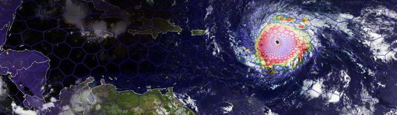
ClusterTech has made a breakthrough in hierarchical time stepping on Model for Prediction Across Scales - Atmosphere (MPAS-A). We will showcase results with a grid size of 1km (0.6 miles), gradually transitioning to 160km (99 miles) resolution outside the region of interest. The approach avoids small timestep on large cells, significantly boosting efficiency. Our professional team will demonstrate ClusterTech Platform for Atmospheric Simulation (CPAS), which allows user-customized meshes. Please come and visit us.
Date: 5-7 June, 2019
Time: 5 June 10:30-17:30/ 6 June 10:00-17:30/ 7 June 10:00-16:00
Venue: Booth 6055, Hall 4, Palexpo, Geneva, Switzerland
What is CPAS?
The ClusterTech Platform for Atmospheric Simulation (CPAS) is a cloud-based service platform which implements hierarchical timestepping on MPAS-A to better serve computational needs of numerical atmospheric model users.
To achieve a balance between accuracy and computational cost, many Numerical Weather Prediction models (NWPs), such as Weather Research and Forecasting Model (WRF(V3.9.1)), adopt a set of rectangular grids where local refinement is achieved by nesting a high-resolution domain inside coarser grids. The Model for Prediction Across Scales - Atmosphere (MPAS-A(V 6.1)) adopts spherical centroidal Voronoi tessellations (SCVTs) covering the globe, while local refinement is achieved using variable-resolution meshes. MPAS-A is a promising model for practical usages. However, MPAS-A uses a constant global timestep, determined by the size of the smallest mesh cell, which limits the resolution variability, as the existence of a high resolution region would make the computational resource requirement prohibitively large.
CPAS has relaxed this restriction by implementing an optional hierarchical timestepping (HTS) treatment in the MPAS-A(V 6.1) dynamic core. Cells of different sizes are assigned with different time step levels. Computational load is substantially reduced for large resolution variation. This creates the new possibility for MPAS-A to be used for high-resolution regional/ local forecast,instead of limited area models such as WRF (Weather Research and Forecasting), enabling customized variable-resolution mesh generation for specific needs. Using CPAS's customized mesh generation service is as easy as drawing polygons on a map panel and entering desired resolution values.
Website: www.cpas.earth

